Protecting Structures From Wildfire Embers and Fire Exposures
Community members and business owners must understand the importance of protecting their structures from ember and fire exposures (radiant, conductive and convective heat).
Posted: Sept. 1, 2022
Updated: Sept. 17, 2024
- 5 min read
- Find similar articles:
- CRR
- Wildfire and WUI
Preparing for all fire exposures, not picking and choosing only one, is vital for improving home and building survival chances.
What your community needs to know
Wildfires spread primarily by:
- Ember generation and deposition. Burning or smoldering pieces of material generated during a wildfire event can land on combustible material.
- Radiant heat. The heat from the fire raises the temperature of a combustible material until that material reaches ignition temperature and burns.
- Flame impingement exposure (conduction). The flame from a fire touches a combustible material and the material burns.
- Convection. The transfer of heat by moving hot gases ignites combustible material.
Along with protecting from fire exposure, hardening homes from exposure to embers that can travel great distances is one important piece in achieving structure survival.
Of these 4, embers (sometimes also called firebrands or flaming sparks) contribute to a significant percentage of home ignitions. These pieces of burning material lofted into the air by winds generated during the wildfire event can be small or large. According to National Institute of Standards and Technology (NIST) research, embers can be carried by winds and deposited several miles downwind PDF from the wildfire. During a wildfire, there can be millions of them generated that could impact a structure.
How embers cause structure ignition
4 primary areas where embers can lead to structure ignition are:
- Landing on the structure.
- Entering the structure.
- Landing on the landscape surrounding the structure.
- Landing on nearby fuels (fences, sheds, woodpiles, etc.)
Make sure these areas are routinely and carefully mitigated. During a wildfire, embers can land on buildings and the surrounding landscape. Also, embers can reach a building's interior through a point of entry, such as a window or vent.
During a wildfire, millions of embers can land on a home and the landscape surrounding the home. That is why it is so important to make sure that the home and parcel surrounding the home, including landscape, fences, outbuildings, etc., are routinely and carefully mitigated.
Interdependent factors
Residents must meticulously protect every potential part of the home and parcel that could become a point of entry for embers. There are many interdependent factors that influence the fire spread. An ember ignition can start a catastrophic chain of events. A single home catching fire can result in neighborhood destruction.
Smoldering
Sometimes embers smolder in flammable materials for many hours PDF before leading to the ignition of fire on areas such as a roof or deck or areas outside the structure of a home or commercial building. Visible flames may not appear until hours after the wildfire flame front has passed.
Take action
To learn about 40 steps that should be taken to mitigate the potential of structure ignition by embers during a wildfire event, check out Table A in Appendix A of the NIST report “WUI Structure/Parcel/Community Fire Hazard Mitigation Methodology PDF.”
Ember research is helping with understanding and mitigation
To protect lives and property, it is important to continue research about the way embers can ignite structures to understand the following:
- Their trajectory.
- How they can be generated.
- The size of embers that can be lofted during a wildfire event.
I recently examined an ember generated by the Marshal Fire in Colorado. The ember, part of a child's plastic playhouse, was 3 feet wide. It landed in vegetation surrounding a business in Superior, Colorado, one-quarter mile away from the wildfire and started a fire in the mulch.
Current NIST ember research includes:
- A Case Study of the Camp Fire Timeline PDF.
- Studies using an emberometer.
- Wind-Driven Fire Spread to a Structure from Fences and Mulch.
Other organizations performing ember research include the U.S. Forest Service Rocky Mountain Research Station and the Insurance Institute for Business and Home Safety.
More research about embers generated during wildfires could help to develop even more effective mitigation improvements in building and home construction and outbuilding and landscape maintenance, including new types of building materials to be used in home and commercial construction. It will also be incorporated into land use and building code development in wildfire-prone areas.
In addition, researching fire spread at the parcel-level to make sure fire — in some cases started by embers — does not destroy structures could result in communities that are much more resilient (sustaining less damage and recovering more quickly) from wildfire events.

Millions of embers generated during the Camp Fire. (Photo: CAL FIRE)
You can guide them with practical, affordable steps they can take to make their buildings and homes safer with proven fire mitigation measures highlighted in NIST's research PDF including:
- Replacing window screens with metal screens.
- Caulking or sealing all openings in the structure.
- Using metal or stone fence materials where a house and wooden fence meet; 5 feet from the house to the wooden fence.
You can also show them that ember hardening should not be viewed as a structure-only activity. The parcel should also be assessed and hardened appropriately to limit fire pathways to a home or business, such as:
- Ember to mulch next to shed to shed building.
- Ember to mulch next to house to building.
- Ember to gutter to roof and rest of building.
Once home and business owners understand how much damage can be caused by embers from wildfires, they should be motivated to take steps to help reduce the risk.
2 New Apps Can Raise Wildfire Risk Awareness in Your Community
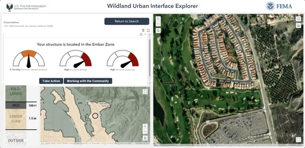
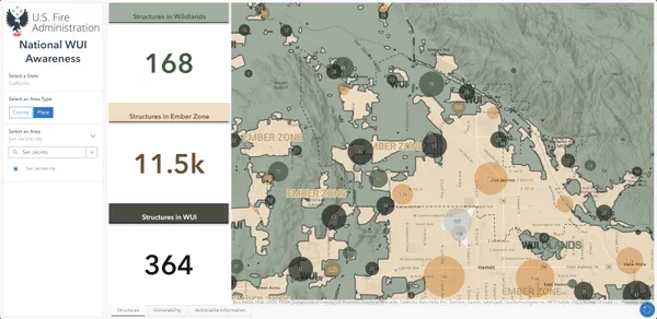
The U.S. Fire Administration has developed 2 new tools you can use to improve prevention messaging in your community. The 2 tools are the Wildland Urban Interface (WUI) Fire Property Awareness Explorer and the WUI Fire Community Awareness Explorer. They provide the initial data-informed basis for residents to “Know Where You Live” in proximity to the location of the WUI and fire-prone areas.
Raising awareness is the first step and serves as the starting point for residents to take action in preparing for and mitigating wildfire loss.

WUI Fire Property Awareness Explorer Application
This application allows users to search addresses or communities to gain a contextual understanding of their area relative to the WUI and vegetative fuels. The application also includes an assessment of a location's structure density and proximity - important factors to consider for creating fire-adapted communities in the WUI and for developing mitigation plans and outreach campaigns.

WUI Fire Community Awareness Explorer
This dashboard provides a quick snapshot of counties or places in the US and potential exposure to wildfire hazards for structures in the WUI. Users interested in building fire-adapted communities and resilience can quickly identify vulnerable structures or areas in the WUI to help inform community risk reduction planning and targeted outreach efforts.
