
U.S. Fire Administration Launches New Tools To Raise Awareness on Wildland Urban Interface Fire
Posted: July 17, 2024
- 3 min read
- Find similar articles:
- Wildfire and WUI
- Data
- CRR
Wildland urban interface (WUI) areas are the subject of increased attention because of the challenges posed by wildfires; expanding WUI areas due to new building development, severe weather, increasing number of structures destroyed, and area burned; and estimated annual wildland and WUI fire damages.
Consider several of the most devastating fire disasters just in the last decade with impact data confirmed. In August 2023, the wildfire-initiated urban conflagration of Lahaina, Hawaii, damaged or destroyed more than 2,200 structures and killed 98 people. In September 2020, the Almeda Drive Fire in the communities of Talent and Phoenix, Oregon, destroyed 2,600 homes and killed 3 people. Roughly 99 million people, a third of the U.S. population, live in the WUI environment, yet most have no idea what the interface is or the dangers that it poses.
Creating fire-adapted communities remains a key priority of national fire safety, prevention and control policy in the United States. Effective and comprehensive — data-informed — community risk reduction programs and mitigations at the local level must be implemented to meet increased fire risks faced by local communities in the WUI.
To support the local fire service and communities in this charge, the U.S. Fire Administration (USFA) recently developed 2 WUI fire awareness tools to raise awareness about where WUI areas exist throughout the United States. The 2 tools are the WUI Fire Property Awareness Explorer and the WUI Fire Community Awareness Explorer. These new tools allow for local fire service and community stakeholders to apply consistent data in the implementation of community risk reduction, code adoption and enforcement, mitigation, and planning efforts. These tools are designed to provide awareness about the location of the WUI and potential susceptibility to fire in areas relative to wildfire hazard exposure.
These tools do not measure or convey risk. They are designed to raise awareness about the location of the WUI and the potential susceptibility to fire in areas relative to wildfire hazard exposure. The WUI Fire Property Awareness Explorer provides the initial data-informed basis for residents to “Know Where You Live” in proximity to the location of the WUI and fire-prone areas. Raising awareness is the first step and serves as the starting point for residents to take action in preparing for and mitigating at the individual resident and property level.
The fire service and community stakeholders are encouraged to use the new WUI fire awareness tools to inform locations in their communities to focus mitigation and risk reduction efforts toward building more resilient, fire-adapted communities.
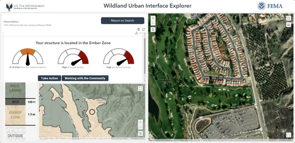
WUI Fire Property Awareness Explorer Application
This application allows users to search addresses or communities to gain a contextual understanding of their area relative to the WUI and vegetative fuels. The application also includes an assessment of a location's structure density and proximity - important factors to consider for creating fire-adapted communities in the WUI and for developing mitigation plans and outreach campaigns.
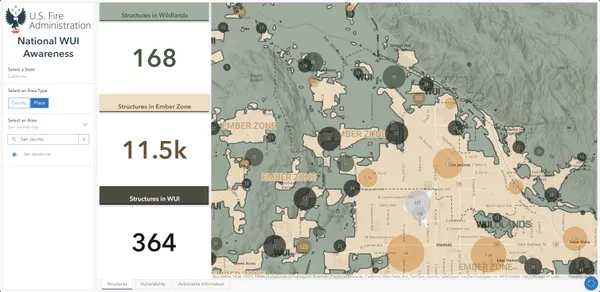
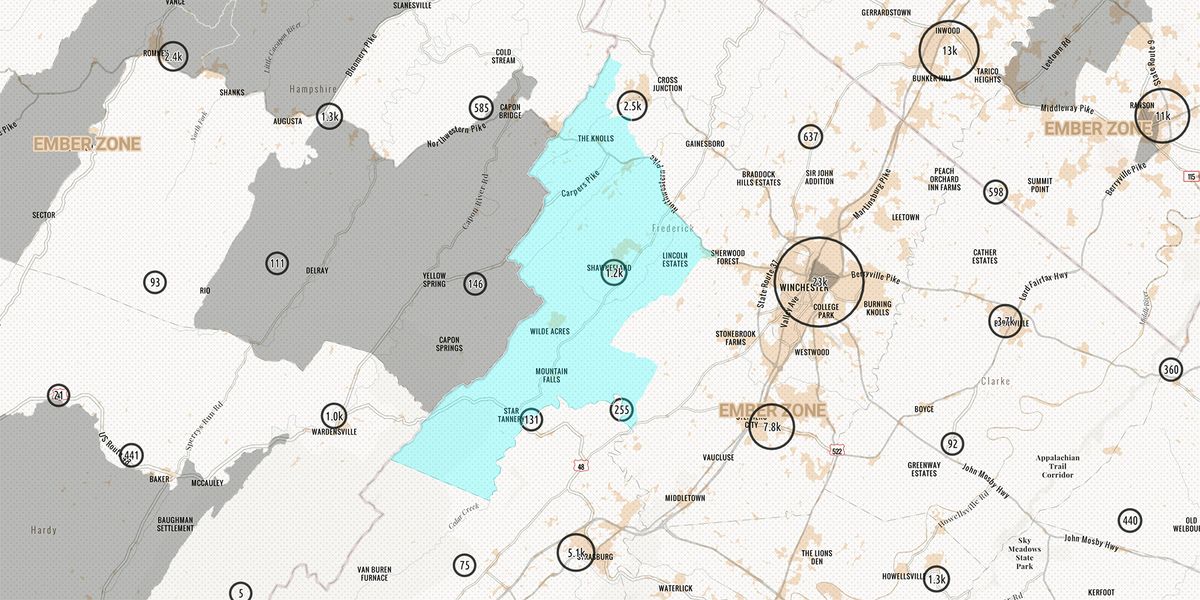
WUI Fire Community Awareness Explorer
This dashboard provides a quick snapshot of counties or places in the US and potential exposure to wildfire hazards for structures in the WUI. Users interested in building fire-adapted communities and resilience can quickly identify vulnerable structures or areas in the WUI to help inform community risk reduction planning and targeted outreach efforts.